![]()
![]()
![]()
|
|
THE HISTORY AND METHODOLOGY OF ROMAN SURVEYING Compiled by: Texas A&M University - Corpus Christi Geographic Information Degree Program
In order to understand the actions of a group of people one must first become familiar with their history, customs and daily life. Rome was a society that was full of history rich with culture and customs and bustling with the day-to-day activities of life.
Rome was founded by an agrarian people living along the Tiber River. Archaeologists date the founding of Rome to 753 B.C. (Rome: The Roman Kingdom). At this time, the early government was a monarchy and was founded on tribal logic. The monarch ruled alongside a senate and assembly, with the senate usually consisting of elders of each of the separate clans. The senate had power to veto the appointment of the king. Fearful of being taken over by the growing Romans, the Etruscans to the north took over Rome and remained in power until 509 B.C. (Rome: The Roman Kingdom). The Romans revolted and set up a republic. In this new Republic power was shared between two consuls each of whom had the power to veto the other's decisions.
The entire concept of Roman society appeared to center on the city. Romans were social creatures, who craved interaction with society and needed a community to correspond with. This is what made the city such an important an integral part of their lives. Roman society was structured into certain classes. The highest rank among the citizens was the senators, and them came the consuls, and finally the equestrians. In this society it was possible to change your social standing. This fact in many ways set Rome apart from other nations. Some individuals had even been known to rise from slave status to that of a representative.
Rome was a nation with thriving industry. Open markets and squares were constantly being filled with merchants who bought and sold goods. Rome was one of the world's leaders in production of luxury goods such as jewelry and precious metals. Bronze, terra cotta ware, and glass were some of the favorite items of the people. The woolen industry was also in high demand due to wool's emergence into earlier fashion. Industry within Rome flourished in large part to its vast, seemingly endless supply of natural resources. The average day for a Roman consisted of a six-hour workday. This compared to modern times seems quite short. Likewise, the holidays for Romans were often very different. During one year, at the prime of Roman society, 159 public holidays appeared on the calendar (Rome: The Roman Kingdom).
Roman society deemed a true citizen one that was well educated. In the early days of Rome education was merely given to one through his or her parents or guardians. Children would usually follow in the steps of their parents learning the family's trade. As Rome grew and became a wealthier nation children would be educated by Greek teachers. The languages of Greece and Rome were studied in depth. Poetry and literature were given high importance during these times. Other topics such as history, geography, and astronomy were also studied to a lesser degree. Greek influence on education was soon seen throughout Roman society. Even plays and theater required the audience's understanding of Greek.
Law and politics was another major facet of Roman life. Lawmakers and representatives held an upper classmanship, which the lower classes constantly struggled to attain. Roman laws were usually codified and structured. This set Rome apart from many of the lawless, barbaric nations. Laws were created for personal protection, taxation, and land transfer.
For years, surveying has been an integral part of society, and has been called "the world's oldest profession". Ancient historical records trace the craft of surveying to the Nile Valley of Egypt. Here surveyors known as "rope-stretchers" surveyed land along the Nile as a basis for taxation. The economy of Egypt during this time period was mainly governed by the periodic flooding of the Nile. During a flood boundary lines and markers were often moved or obliterated. Egyptian rope-stretchers would replace these markers after the flood to determine the amount of arable land and inventory the property for a likely tax yield. Later in the year, during the harvest season, officials would visit the property with a surveyor to assess the final tax.
During this time period, Egypt would often be visited by a maritime society from the north. The Greeks, on visits to Egypt, learned the value that could be offered by the surveying of land. Greek philosophers, who had developed the science of geometry, applied this knowledge to surveying around 120 B.C. (Dilke). Greece, unlike Egypt, was a hilly, mountainous country with few areas of flat land, and there is no evidence of systematic land surveying. Cities and towns were usually divided into irregular sections because of the constant change in the layout of the land.
Greek society was filled with scientists and mathematicians. Tunnels built with extreme accuracy were laid out by an early Greek surveyor by the name of Polycrates. The Pythagorean Theorem, one of the most widely used theorems in math, was developed by the Greek Pythagreous. Scientists in Greece also studied literature and astronomy, but one subject that was given great importance was geodesy. Erasthones of Greece has been credited with the first accurate calculation of the circumference of the Earth. This calculation came at a time when many claimed the Earth to still be flat.
Roman land surveying is in many ways indebted to the previous societies of Egypt and Greece. Each group of people had its own contributions to Roman surveying. Egyptians, with their methods of land division and record holding and Greeks, with their in-depth knowledge of mathematics, science, and planning both made immeasurable impressions on Roman society. Roman land surveyors, or Agrimensores, measured Roman lands with careful planning and unprecedented accuracy. The Romans, like the Egyptians, were a nation of farmers and early surveying practices of the Romans was to mark the boundaries of a new town by plowing a furrow with an oblique plow. This action showed, at an early stage in Roman society, that surveying was used to set boundaries and the limits of plots of land. Boundary stones were often incorporated with the furrow to denote a sense of permanence. Agrimensores were very important people in Roman life. Surveyors in Rome saw their status continue to rise as more land was conquered. Due to their vast knowledge of land law, agrimensores became judges in cases of land disputes. Boundary definition in Roman times was of utmost importance. The tampering or removal of boundary stones was strictly forbidden. Boundary stones during Roman times often had certain religious connections. During such a ceremony, ashes and offerings would be spread over the stone to sanctify the monument. It has been documented that animal sacrifices had even taken place in certain parts of Rome when establishing boundary corners. These boundary stones were usually made of hard rock or flint and were usually four feet long, with one and a half feet protruding above the ground.
Due to the fact that surveying and boundary definition was so important, Rome realized its surveyors had to be well educated in many different fields. In the beginning of Roman society, the educational system place heavy emphasis on the arts. Surveying this time was actually regarded as a liberal art. Roman surveyors had to be fluent in both Greek and Latin in order to study certain texts. Surveyors were given a broad education encompassing history, philosophy, music and medicine with an emphasis on mathematics, astronomy, cosmology, and law.
One of the main sources of information on land surveying was the Corpus Agrimensorum. The Corpus was a collection of surveying manuals that had been handed down over time. It was duplicated and illustrated by monks to allow students who were far from education centers like Alexandria to familiarize themselves with the subject. The use of such illustrations was a great leap forward in terms of education and served a purpose similar to today's distance learning. The Corpus covered many surveying disciplines and even covered topics such as the surveying of military encampments and works on Rome's water supply.
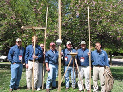
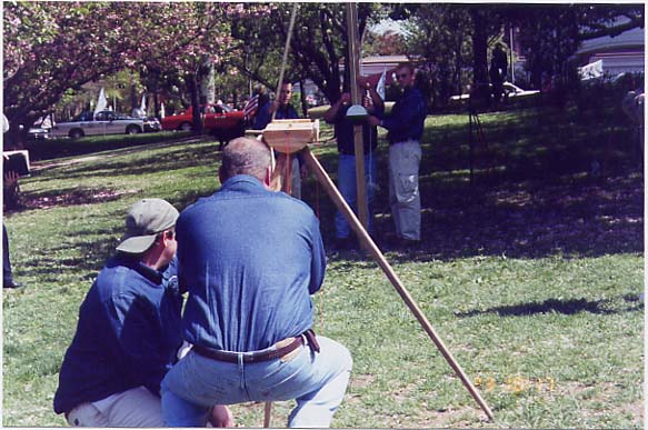
Along the theoretical training, Romans also acquired practical surveying knowledge with the use of several instruments. The main surveying instrument used by the Romans was the groma (Roman Surveying). The groma consisted of cross arms that were perpendicular to each other, with plumb bobs hanging from each arm. The cross arms themselves were mounted on a tall staff. This instrument was used to set out straight lines and right angles. This type of measurement was mainly used in the division of land, which to the agrimensore was of primary importance. Romans typically preferred the division of plots of land to be made in squares instead of rectangles. This fact is what makes the groma such a valuable tool. Another instrument often used by agrimensores was the chorobates. This instrument was a leveling device often used in the the construction of the aqueduct systems throughout Rome. The chorobates was a rod 20 feet long with duplicate legs attached perpendicularly at each end. Diagonal pieces connected the rod and the legs. Both diagonal members had vertical lines driven in them over which plumb bobs are hung. Atop the rod was a water level groove that is used when wind interferes with the plumb bobs. During calm days leveling was accomplished by positioning the instrument so that the plumb bobs strike both of the scribe lines on the rod. The chorobates is considered the most accurate leveling device of Roman times.
The Roman surveyor used as its basic measurement the pes or Roman foot (Dilke). The Roman foot was approximately 11.6 inches long (Dilke). This measurement was usually used for smaller distances, such as for urban parcels or with the measurement of buildings. For larger distances associated with the division of plots of land, the agrimensore would choose the actus, which equaled 120 Roman feet. The passus, used primarily by military surveyors, was actually a double pace or 5 Roman feet. This unit of measurement is used to derive the Roman mile, which is 1,000 paces or 5,000 Roman feet (Dilke).
As stated before, Rome was an agrarian society, so many of its measurements have roots in agricultural lore. The iugerum, which is a unit of measurement for the allocation of area, was roughly 5/8 of an acre. It was based on an agricultural measurement that was said to equal the amount of land that could be plowed in one day. One of the main concerns of the agrimensore was the division of lands in a method known as centuration. Centuration divided lands into squares and sometimes rectangles. The normal century was 2,400 Roman feet by 2,400 Roman feet, giving an area equal to 200 iugera (Dilke). The groma was the primary instrument employed in centuration because of its ease in setting right angles. As Rome continued to grow, the lands known as "ager publicus", or state lands, continued to increase. Once land was divided and boundaries were set inhabitants of this land could live in harmony. In retrospect, this was the most important contribution Roman surveyors gave to Roman society. Without clear boundaries and a solid framework of land records, Rome may never have risen to the great society that it eventually became.
Without the education, development and structured methods of surveying, the enormous engineering feats that Roman engineers accomplished would not have been possible. Due to the fact that the Romans were such an urbanized society, planning and engineering were of prime importance when dealing with the development of cities and towns. The construction of temples, theaters, baths, amphitheaters, markets, and shops had to be constructed with the utmost care. With the influx of large amounts of people into Roman cities, Roman planners and engineers had to concern themselves with the question of how they would provide water to mass amounts of people for drinking, sewer and waste removal, and bathing. Water has always been a necessity for human life on earth. In today's society, one can easily be found guilty of taking this necessity for granted. In early Roman times, cities were usually located near lakes or along streams where water could be hauled by hand to and from its source. As cities grew, the need to bring water to the cities was an ever-present problem for Roman engineers. Roman engineers attempted to solve this problem by installed aqueduct systems to bring water into the city.
Roman aqueducts were simple in nature. At first, they were merely hollow channels bored through rock so that water could flow from its source to the different cities and town throughout Rome. The only source of energy that moved the water was the force of gravity (The Roman Aqueducts). Due to this fact, most of the water sources chosen were located in high mountainous regions above neighboring cities. Surveyors had to plot courses following the lay of the land with each successive point being somewhat lower than the one before it. This in itself was quite a problem. When the aqueduct reached canyons or gorges, a bridge or viaduct was built to carry the water and maintain the proper elevation. As the water moved out of the mountainous regions to the lower flat land in which the cities were located, high archways were built which carried water for miles before entering the city and being collected into large cisterns. These giant cisterns were then mounted with several large lead or earthen pipes to carry the water to different homes and buildings. The building and construction of these aqueducts was a culmination of planning, surveying, engineering, and practicality. The aqueduct brought more than water to cities, it caused them to flourish with people and culture. Without such an invention the immense size and shape of Roman cities would not have been possible.
In 312 B.C., Censor Appius Claudius had the first aqueduct built, measuring approximately eight miles in length (The Roman Aqueducts). The construction and surveying of aqueducts were therefore expressed in the military unit of "passus", which was a measure of approximately five Roman feet. The construction of such projects took many laborers, engineers, and surveyors all working under the constant supervision of a high-ranking officer known as the "curator aquie", or water curator. Sextus Julius Frontinus left behind many notes and insights into the building of the aqueducts in a manuscript known as "De Aqua Urbis Romae." This book describes in graphic detail, the length, sources, and functions of each of Rome's aqueducts. Frontinus was a well-educated man with much knowledge of land surveying and engineering, and had strong ties to those in high-ranking governmental positions. This broad background of expertise made him one of the most well-known and revered curators of his time.
With the continued growth of cities in Rome came another problem. In order for the large nation to thrive it had to be linked with miles and miles of infrastructure. With such large borders and extensive area, Rome had to have a way to protect and unite its people and this was done through the construction of roads. Roads also had to be in place so that the trade and the economy of Rome could flourish. Prior to the Romans, roads were merely dirty paths with mounds and potholes that severely hampered long distance travel. Around 45 A.D. Romans began to build and construct roads on a massive scale (Bithynian Geography, Town, and Tribes). In true Roman fashion, the design and fundamentals of road building were thought out to ensure the safety and longevity of the road itself while simultaneously protecting those that used it. Roman roads, as a whole, were laid out in straight lines to ensure the shortest distance between two neighboring towns. The surveyor using the groma could align the roads with a high degree of precision, and later, with the chorobates, could level slopes and grades for water shed. The actual building of the road was divided into four stages of construction. The first step in the construction of a road was to remove three feet of soil to form a ditch for the stability of the road. The bed of this ditch was then stomped for stability and filled with a lime mortar. Stones were then layered on top of the base mortar. These stones are smaller in diameter and usually ranged from four to five inches in diameter. These stones reinforce the compacted lime base. After these layers were finished and set, the crown of the road was leveled and prepared for use. The new roads enabled troops and equipment to be moved in great distance in a fraction of the time it would normally take. Trade benefited from the introduction of roads by giving merchants the ability to move goods between towns much faster and easier with less risk of damage to their goods. Roads in Roman times helped unite a people and bring the nation to the height of its rule.
Rome was a nation unlike any other at the time. It was a structured society with laws and policies to guide the nation as a whole. It was a nation with a deep sense of history and rich culture. The advances made by Romans in their surveying have had lasting implications on the methodologies of today. WORKS CITED
Stambaugh, John E. The Ancient Roman City. John Hopkins University Press, 1998
Peterson, John A glossary of terms used in Roman land surveying. Available online at http://www.sys.uea.ac.uk/Research/researchareas/JWMP/glossary.html
Roman Surveying Available online at www.surveyhistory.org
O. A. W. Dilke, The Roman Land Surveyors New York, 1971
Rome: The Roman Kingdom Available online at http://www.wsu.edu/~dee/ROME/KINGDOM.HTM
The Roman Aqueducts Available online at http://www1.union.edu/~mullerc/aqueducts.html
Bithynian Geography, Towns, and Tribes online www.students.ou/c/richard.d.cochran/html
|
|
|