The Surveyor's Basic Tools

Back Home Next

One of the main tasks of a surveyor is to measure the surface of the earth.  This display is representative of the early tools used by the surveyor and briefly describes their purpose and uses.

The Chain
This is an example of a "chain" that is normally 66' long consisting of 100 links.  A "chain" of 66' can also be described as being 4 poles of 16.5'.

Other tools used by a surveyor to measure distance can be a steel tape of lengths of up to 500' and the modern electronic distance measuring devices that can measure distances in excess of several miles with the use of reflector prisms.

In fact, the first men to land on the moon left behind a grouping of reflector prisms that allowed surveyors and scientists to measure the distance from the earth to the moon to an accuracy of just a couple of feet.


The Compass
A surveyor uses a compass to determine the direction of a line.  the compass needle points to the MAGNETIC NORTH POLE and by turning the compass in the direction of the line being surveyed, the direction of the line can be observed.  Although there are many varieties of compasses, they all fall into two main categories: either a "plain" compass or a "vernier" compass.

A plain compass has no adjustment and always reads magnetic north.

A vernier compass has an adjustable scale that allows for the "setting off" of the magnetic declination and the compass can then directly read true north.


The Transit and Theodolite
 

Transit

Theodolite

The transit and theodolite are used by the surveyor to measure both horizontal and vertical angles.  While the purpose of the two is similar, as a general rule a theodolite is more accurate than a transit.  However, there is no specific rule as to when one definition ends and the other begins.  Generally, these instruments have a minimum accuracy of one minute of angle and some very precise theodolites will measure angles to an accuracy of one-tenth of a second of angle.  To put these accuracies into perspective, at a distance of one mile, one minute of angle covers about 1.5 feet.  At a distance of one mile, one-tenth of a second of angle covers about 0.003 feet.

The Level
 
Wye Level Automatic Level
                                

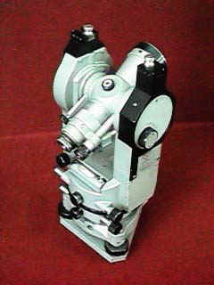
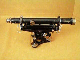
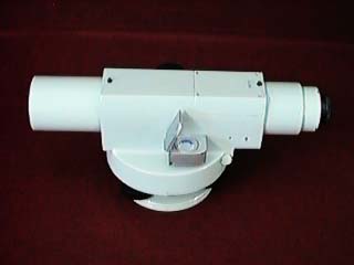
The surveyor uses a level to determine elevations.  Levels fall into three broad categories:  a "dumpy" level, a "Wye" (or 'Y') level, and "automatic" level.  As with all tools of the surveyor, there are various degrees of accuracy within each category of level.

A "dumpy" level has a telescope with cross hairs permanently mounted in a pair of arms.

A "Wye level has a telescope with cross hairs that is removable from the arms.

An "automatic" level is basically a dumpy level, but it has a built in compensator that automatically adjusts for minor errors in the set up of the instrument.

In conjunction with a level, the surveyor will use a "level rod" to read an elevation up or down from the level of the telescope.  From these observations, a surveyor can determine differences in elevation of different points or transfer an elevation from one location to a distant location.


The Solar Compass
The solar compass is a compass with a very special purpose of easily determining "Latitude" and "True North".  The solar compass was invented in 1835 by William Austin Burt of Michigan after he had discovered the iron deposits located in the state and concluded that a regular compass would give such erroneous readings as to be almost useless.  By making observations on the sun or other stars, the latitude of the location can first be determined and then "True North" can be determined.  The solar compass also has the ability to measure horizontal angles much like a transit.

The solar compass was such an important invention that within a matter of a few years it was required by law to be used on the surveys of the public lands.

William Austin Burt also made another significant invention.  In 1829 he patented the first "typographer", or as we would refer to it today, the typewriter.


Back Home Next