![]()
![]()
|
|
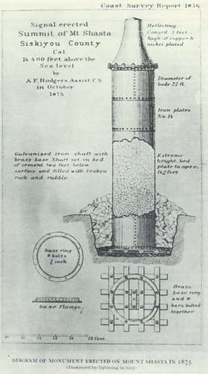
The following is excerpted from the book "The Mount Shasta Story: Being a Concise History of the Famous California Mountain" by Arthur Francis Eichorn, Mt. Shasta, Calif.: Mount Shasta Herald, 1987. Half Folio. 37pp. The Geodetic Monument, 1875-1903 By: Arthur Francis Eichorn, Sr. 1954
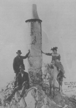
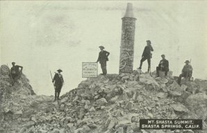
Near the south base of the summit pinnacle of Mt. Shasta, at about the 14,000 foot level, may be found a large, round, metallic object having the appearance of a hot water tank or boiler. This is the remains of the long forgotten Geodetic Monument that withstood the ravages of the elements for a period of nearly thirty years. From 1875 until 1903 this monument was proudly perched on the summit of Mt. Shasta. Since there exist several versions pertaining to the history of this monument, we have spent a good deal of time sifting fact from fancy, and with the kind assistance of Mr. Edward Stuhl and George Schrader of Mount Shasta, it is now possible to offer the true facts of the brief existence of the monument. In the year 1874, it was planned to determine the magnitude and secure measurements of the vast area comprising northern California. Because of Mt. Shasta's towering dominance over the region, it became a desirable position to establish a geodetic signal station. A permanent signal man stationed on the summit would have been ideal for this project. However, due to the extreme cold and the altitude plus the uncertainty of a steady source of supplies, such a plan was impracticable. Therefore, it was decided to design an un-manned signal device that could be mounted on the summit of Mt. Shasta, which would provide a constant signal to connect the long lines of the main triangulation of the Coast and Geodetic Survey, in conjunction with other established points at unusual distances. Work was begun on the plans, and the original blue prints for the signal monument offered a selection of three possible forms. The plan ultimately selected is the one shown in the accompanying text. Captain A. F. Rogers [sic] of the United States Coast Survey was the supervisor in charge of installing the monument on the summit. He was fortunate in enlisting the service of John Muir to make the preliminary survey and select a site for the monument. This work was carried out successfully by Muir in the spring of 1875. The gross weight of the monument was approximately 3,500 pounds, which of course made it necessary to have it carried to the summit in small sections. Mr. J. H. Sisson, the noted innkeeper and pioneer guide from Strawberry Valley, was awarded the contract to transport the monument material to the summit. The agreed price for the undertaking is reported to have been seventy five cents per pound. The sections were conveyed by pack animals to an elevation of 11,000 feet, from here they were carried to the summit by Indian packers employed by Sisson. From a Southern Pacific Railroad brochure of 1888 we learn: "The conoid and cover weighing 68 pounds, was carried by Indian packers, in the ordinary method of carrying their grasshopper and seed baskets - with the greatest weight uppermost, the weight divided between shoulders and back and suspended by a broad strap passing around the forehead. "The shaft sections were carried in canvas covers and weighed 26 pounds each. The entire shaft, which weighed about 3,500 pounds, was delivered on the summit in four days, from Strawberry Valley. The conoid was of copper, nickel plated and burnished and its light could be seen, as far south as Mt. St. Helena, 192 miles away." An interesting variation regarding the method used in transporting the monument material to the summit is told by F. H. MacNeil in his article in Mazama, 1915: "The various parts were packed to the top by Indians from McCloud. Local history has it that the braves, after starting out with their loads, shifted them to the backs of their squaws, and made the climb in comfort as they watched the women struggle under their burden." When all the material was finally transported to the summit, the sections were riveted together and bolted to its base. The inside of the shaft was filled with small rocks and the conoid top was then bolted in place. The monument was set in a hole which was filled with rocks and boulders to weight it down. This work was done by four men under Captain Rogers' supervision, August Mather, G. Knox, Francis McLaughlin and John Layng. The work was finally completed in October, 1875. In 1878, the first successful contact was made with observers on Mt. St. Helena, a distance of 192 miles to the south. B. A. Colonna of the Coast and Geodetic Survey was the man who achieved this mission by exchanging flashes with observers on Mt. St. Helena. He also distinguished himself by remaining on the summit for nine successive days and nights. After the geodesy work was completed the monument was neglected. Its only use over the intervening years seems to have been its use as a focal point in photographing climbers reaching the summit. It also became popular as a bulletin board where climbers inscribed their names and dates of their climb. This fact is quite apparent as shown in the accompanying photographs.
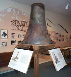
At this point in the history of the monument, we come to the controversial question regarding when and how the monument disappeared from the summit. Many sources state that the monument was blown from the summit, and also claim the year as 1905. This supposition was mentioned by F. H. MacNeil in an article in Mazama, 1915, in which he states: ". . .in 1905, the monument collapsed during a terrific storm. The forest observer on Mt. Eddy,across the valley to the west 15 or 20 miles, is said to have been looking at Shasta with glasses when he saw the monument disappear." Exactly where MacNeil obtained this information is not known. We do know, however, that there was no forest service lookout station on Mt. Eddy prior to the year 1910, and there was no forest service observer on the mountain prior to 1909. Therefore, MacNeil's story was evidently secured from some source that lacked complete knowledge on the subject. Exactly how the monument became dislodged from its place on the summit is unknown. Several theorists maintain, that it was without a doubt, blown from the summit by the high winds that prevail about the summit. Others are equally emphatic in supporting the theory that it was blasted from the summit by lightning. Since no one actually witnessed this particular phenomenon, it can only be conjecture to say how it fell. From its appearance after it fell it is easy to see why the lightning theory has so many supporters. The entire monument bears evidence of having been hit. This is apparent by the many holes fused in the shaft and top. It seems quite plausible, that the monument met its fate through the combined assault of both high wind and lightning. Only the elements know the answer to this mystery. When the monument fell, can be closely determined. It has been established that the monument was still standing in August 1903. George Hamlin Fitch, who with a party climbed Mt. Shasta in August 1903, saw the monument standing in its place. His narrative, "How to Climb Mt. Shasta" appeared in the Sunset magazine, San Francisco, October 1903, pages 529-536. During October, 1903, however, we know for certain that the monument was missing from its place on the summit. This fact was corroborated by a letter shown me by Mr. Edward Stuhl of Mount Shasta. From this letter we learn: "Owen B. French, professor of geodesy at George Washington University, who directed the field work of the United States Coast and Geodetic Survey for an Ark of primary triangulation, stated that in October 1903, while working on Shasta, he did not see the monument on the mountain." In 1904, persons climbing the Shastina peak also reported the absence of the monument. A search in 1904 and 1905 failed to disclose where the monument had fallen to. The accepted supposition at the time was, that it had fallen over the eastern precipice and had come to rest somewhere near the foot of the Wintun Glacier. We find mention in Ansel Hall's article in the 1926 Sierra Club Bulletin, supporting this belief: "Who knows how many generations will pass before this strange and mysterious instrument will emerge at the foot of the Wintun Glacier, and what conjecture it will occasion." Actually the monument had fallen to the south, and from its later appearance it shows indications that it turned end over end. This can be noted in the photograph showing the monument lying on the slope of the summit pinnacle. The top is bent where it struck and the bars on the bottom of the shaft are rounded, indicating that the monument rolled end over end. After falling, the monument finally came to rest near the base of the summit pinnacle, with the top pointing uphill. Apparently it was soon covered with snow and it remained entombed for several years. I have been unable to determine when the monument was found After it fell. I have talked to many local people who have climbed the mountain after 1903, but the earliest information I could uncover was that is was seen lying partly buried in the snow around 1912. The remains of the monument can only be seen during late summer, since it lies near the edge of the perpetual snowfield that covers the region at the base of the summit pinnacle. It lies near the base of the north peak, on the south slope. In later years when it became known that the monument was still intact, certain historically minded people investigated the possibility of having it re-erected on the summit. This project was soon found to be prohibitive because of the cost involved. Also later surveys showed that the lower section of the monument had been damaged beyond repair. It was then, that various plans were formulated to bring the monument top down. It was suggested that the conoid top be removed and melted down into two plaques, one to be put at the Sierra Club Alpine Lodge, and the other to be placed at the summit. Still another suggestion, which had much merit, was to build a new base for the top, much shorter than the original shaft, about three feet in height, with a door in it, so that it could be used as a depository for the summit register book. The important problem at the moment, however, was to get the monument top down from the summit. The Siskiyou County Historical Society actually started a fund to help restore the monument in any acceptable form. Interest wasapparently lacking since the fund never amounted to more than sixty dollars. For some unknown reason, rumor developed that it would be worth several hundred dollars to anyone who could bring the conoid top down from the summit. Three young men became interested in the project, John E. Richard, custodian at the Sierra Club Alpine Lodge, and Glenn Lybarger and Dick Albert. Without going into detail, the three men succeeded in bringing the monument top down from the summit plateau. It took four climbs to the summit by Richard, two climbs by Lybarger, and one by Albert to complete the preparations and bring the monument top down. In addition there were several climbs part way up the mountain and back to complete the project. The conoid top was left in the Mount Shasta Herald office for safekeeping. Richard in the meanwhile was busy with negotiations pertaining to his fee for packing the top down from the mountain. Because of an unfortunate misunderstanding, he was not to realize the large fee he had anticipated. He therefore tried to sell the conoid top elsewhere. After several unsuccessful attempts to sell the monument top to various organizations, he accepted a fee of two hundred dollars for his efforts. This amount was paid by personal check by an anonymous party, and the monument top was donated to the Siskiyou County Museum. The conoid top was then removed from the Mount Shasta Herald office and taken to Yreka, California. For some obscure reason it was eventually taken to an automobile body repair shop and the dents were straightened out. It was then placed in the museum where it now rests in peace among the other objects of antiquity, far from the fury of the elements which drove it from its lofty perch on the summit of Mt. Shasta.
|
|
|