![]()
![]()
![]()
|
|
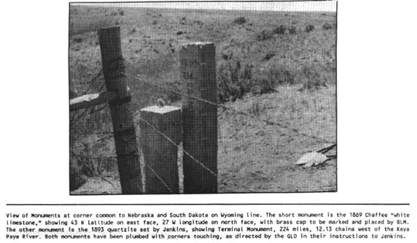
SHOVELS AND PLUMB BOBS by Rollin C. Curd On June 19, 1988, members of the Fall River and Sioux County Historical Societies, accompanied by five land surveyors, journeyed to the common corner of Nebraska and South Dakota on the Wyoming line. Along the way, we visited 10 historical ranches and two abandoned post office sites and the Cheyenne-Deadwood Freight Station. Upon arrival at the state corner, the two monuments were viewed and photographed by many of the 56 persons traveling on the annual Sioux County Historical Trek. Surveyors Dennis Bland, from Cheyenne; Gene Thompson and Kent Kennedy, from Lincoln; Bruce Jensen from Valentine; and Rollin Curd from Chadron, assisted by Historical Society members using shovels, bars, lariats and man power, moved the two monoliths to their original plumb positions. Surveyor plumb bobs were used to check the finished work.
When Chaffee set the monument, he wrote in his field notes the following: "It is surrounded by a mound of earth and stone 7 ft. in diameter at its base, 6 ft. in diameter at top and 3.5 ft. high. It stands in a small broken hollow without any natural objects available for witnesses and nothing striking to the attention. The surfaces rise towards the N., E., and W. and furnishes nothing which would attract attention or furnish material for a sketch. The soil is clay of the poorest quality." Astronomer Chauncey Wiltse received a General Land Office contract in 1874 to survey the Nebraska-South Dakota Boundary, beginning at the intersection of latitude 43o and the Keya Paha River and ending at the Chaffee monument. Wiltse measured the distance 224 miles, 12.13 chains along the 43rd parallel. He set 7-foot by 6-inch by 6-inch cottonwood or cedar posts and charred blocks at one-mile intervals and established four astronomical stations along the line. Only one of the astronomical stations has been found; it is located north of Chadron. In 1880 Robert Harvey was the next surveyor to come on the scene when he surveyed for the 7th Guide Meridian, located four miles east of and parallel to the Nebraska-Wyoming line. George L. Fairfield subdivided T35N, R47W in 1883 and created another state corner 450 feet north of Chaffee's monument. He created another Nebraska-South Dakota line between the Wyoming line and milepost 221. In 1887 Rollin Reaves surveyed north from the Chaffee monument to latitude 46o, marking the Wyoming-South Dakota line. A surveyor George W. Cooley started section surveys in South Dakota in 1890. He ignored Fairfield's survey and used the Chaffee and Wiltse surveys. The General Land Office issued a contract to Joseph Jenkins in 1893 to retrace Wiltse's survey and place quartzite monuments at half-mile intervals beginning at the Keya Paha River, running west to Chaffee's monument, then running east from Keya Paha river to the Missouri River. Today we view the quartzite monument by Jenkins. These monuments were quarried and marked by stone masons in Sioux Falls, S. D., area and shipped by rail to towns along the border. Teamsters transported these stone monoliths to the surveyors. The monuments are marked SD on the north face, N. on the south face and the miles west or east of the Keya Paha River. In 1904 U. S. Surveyor Edward F. Stahle started the survey for the Wyoming-South Dakota boundary at the Chaffee monument. In 1908 he retraced the Wyoming-Nebraska boundary and set granite posts for mileposts and re-established the closing corners by setting brass caps. In 1922 Robert Harvey, a past Nebraska state surveyor, wrote a letter to the General Land Office bringing to their attention the two locations for common corner to three states. The General Land Office and the Law Review Board held that Fairfield's corner was fraudulent and his line easterly to MP 221 was null and void. Plans are underway to complete the restoration by September 6, 1989, at an estimated cost of $3,000. Since the two monoliths are located on the edge of a ravine, an earth berm is required to stabilize the soil and discourage erosion. A commemorative brass cap will be set in the original Chaffee monument and a suitable plaque will be dedicated at the site 120 years after Chaffee set the "white limestone monument."
|
|
|