|
 Article taken from "Backsights"
Magazine published by Surveyors Historical Society
Article taken from "Backsights"
Magazine published by Surveyors Historical Society
|
HADRIAN'S
WALL: THE ROMAN FRONTIER IN BRITAIN
by Mary M. Root
A wise military strategist, the Roman
Emperor Hadrian (117-138 A.D.) realized the futility of trying to subdue the
Celtic tribes. Successful Roman warfare depended upon a fight in open space,
where waves of infantry could pound the enemy mercilessly. The forested hills
and dales of Scotland favored Celtic guerrilla-tactics, especially ambush.
Hadrian selected the limits based on the land’s topography: Hadrian’s Wall
is a fortified boundary line.
Built in A.D. 122 by three Roman
Legions, the Wall with its fortifications linked a series of turrets, garrison
castles, and stationary, military camps along seventy-three miles of windswept
moor. The Wall hugged the north rim of the River Tyne, thereby commanding the
vicinity’s water supply and the hills above. Rather than Scottish forests,
Roman sentries instead controlled the bleak and desolate moor stretching between
the Irish and North Seas. The Roman surveyors and engineers traveling with
Hadrian established the Wall’s position, maximized the use of local materials
and talent in its speedy construction, and designed advantages for every Roman
defender. "In pursuing its course from sea to sea, the Wall seldom deviated
from the shortest and straightest course it could follow, and then only within
the evident design of seizing neighboring elevations that would have otherwise
commanded its position."¹
When first constructed, the Wall stood
about 15 feet high, 10 feet wide at the base and seven and one half feet wide at
the top. It is believed that an embattled parapet rose above the wall proper, to
protect sentries on patrol. To the north a short distance a ditch averaging 25
feet in width and 10 feet in depth strengthened the defense. To the south,
another ditch was created, with the excavated earth forming mounds along either
side. Today this ditch is known as the Vallum, although the Roman word means
"mound." The Vallum was the actual boundary line of Pax Romana
and the official limit of the Roman Empire, and as such, was probably
constructed first and used as an offset to the Wall, and for defense of the
construction crews.
Local availability of materials
counseled the Wall’s construction: stone was used for the 43-mile-long eastern
portion and earth was used on the remaining 30 miles to the west. The stone
blocks were generally 9 inches deep, 10 inches high, and ranged between 15 and
20 inches long. The stone faced an inner core composed of concrete and rubble.
The earthen portion was an early example of cut and fill engineering; the Wall
was formed with material excavated from the ditches.
 It took three years to build the Wall
and its fortifications. This was accomplished by three of the mobile forces
known as a Legion. More than five thousand strong, a legion was an infantry
force organized into ten cohorts, nine of them numbering about 500 men each.
"The First Cohort was a special unit of almost double strength that
included fighting troops as well as specialists and clerks of the headquarters
staff. The ordinary cohort was subdivided into six centuries, or companies, each
of which contained about 80 men under the command of a career officer, the
centurian. Still smaller units were formed by the division of each century into
10 sections of eight men - contubernia, ‘tent parties,’ so called
because in the field they shared a leather tent. On the march, each contubernium
was provided with a mule, which carried the tent plus construction equipment.
According to first-century AD historian Josephus, this equipment included a saw,
a pickaxe, a sickle, a chain, a rope, a spade, and a large basket for moving
earth."² Every legion included a body of specialized soldiers known as
immunes; their skills earned them an immunity from routine duties. The list of
immunes included architects, surveyors, plumbers, medics, stonecutters, water
engineers, ditchers, blacksmiths and clerks. It took three years to build the Wall
and its fortifications. This was accomplished by three of the mobile forces
known as a Legion. More than five thousand strong, a legion was an infantry
force organized into ten cohorts, nine of them numbering about 500 men each.
"The First Cohort was a special unit of almost double strength that
included fighting troops as well as specialists and clerks of the headquarters
staff. The ordinary cohort was subdivided into six centuries, or companies, each
of which contained about 80 men under the command of a career officer, the
centurian. Still smaller units were formed by the division of each century into
10 sections of eight men - contubernia, ‘tent parties,’ so called
because in the field they shared a leather tent. On the march, each contubernium
was provided with a mule, which carried the tent plus construction equipment.
According to first-century AD historian Josephus, this equipment included a saw,
a pickaxe, a sickle, a chain, a rope, a spade, and a large basket for moving
earth."² Every legion included a body of specialized soldiers known as
immunes; their skills earned them an immunity from routine duties. The list of
immunes included architects, surveyors, plumbers, medics, stonecutters, water
engineers, ditchers, blacksmiths and clerks.
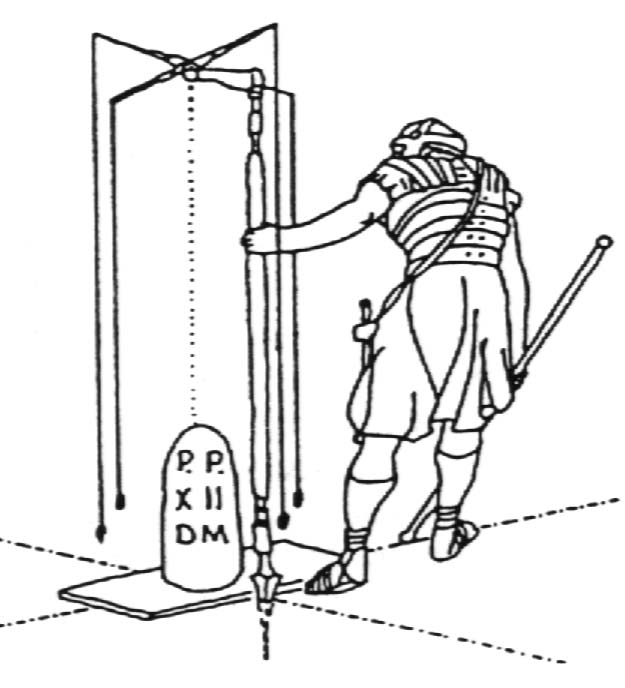
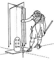 The military surveyors, known as
mensors, carried a Groma with them for laying out right angles, a
decempeda (a 10-foot rod) for measuring short distances, a waxed cord or
rope for measuring longer distances, a plumb line level known as a libra,
and writing and drawing materials. The mensors were responsible for the
overall position of the Wall, the stationing along its length of turrets,
mile-castles, and forts, and the interior layout of each fort. To establish
unerringly a line across Britain at just the point where the land was most
narrow was quite an achievement. It is thought that the Roman surveyors
performed the initial layout by lighting fires on hilltops, and "lining
themselves in" along the lowlands. Once the line of the wall was
established, the distances between structures were measured and marked. Turrets
occurred every 1600 feet. These were small stone towers, thought to have been
surrounded by wooden walkways. Turrets are sometimes referred to as signaling
stations, but it is not known what devices or codes the Roman sentries might
have been using. The "mile-castles"were established every 4,860 feet
(a Roman mile), and were square fortresses housing a garrison of 32 men. In
addition to patrolling the Wall, their duty was to protect the double gates that
marked a crossing point between "civilized" and "barbarian"
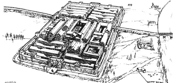
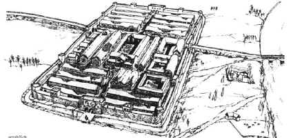
worlds. The stationary military camps were very large, and occurred along the
Wall approximately every four miles. Here the mensors laid out a rectangular
grid of streets, walkways and buildings. The layout was practical, military, and
predictable. Soldiers hailing from many parts of the Empire could orient
themselves wherever they found themselves stationed. The praetorium, or
headquarters, was centrally-located. Around it were grouped the quarters of
staff and bodyguard. Beyond this was a forum where the soldiers could meet, and
again behind this the quaestorium, or paymaster’s office. Adjoining
blocks contained the hospital, the foot-soldier’s barracks, kitchens,
storehouses and granaries, workshops, stables, and baths. Yes, even in this
remote outpost the Romans enjoyed the luxuries of plumbing. "There were
centrally heated communal baths as well as latrines. The toilets consisted of
wooden seats placed over a channel into which water could be poured to flush the
waste into a refuse ditch. In the baths, furnaces heated bronze boilers that
supplied steam and hot water. Besides cold or heated pools, the facilities
frequently offered a dry-heat sauna chamber and a steam bath. They were focal
points of the soldiers’ off-duty hours."³ There were other pastimes to
fill the lonely posting: archeologists have uncovered remnants of board-games,
drinking cups and flagons, letters written from home, and small shrines for
worship. The military surveyors, known as
mensors, carried a Groma with them for laying out right angles, a
decempeda (a 10-foot rod) for measuring short distances, a waxed cord or
rope for measuring longer distances, a plumb line level known as a libra,
and writing and drawing materials. The mensors were responsible for the
overall position of the Wall, the stationing along its length of turrets,
mile-castles, and forts, and the interior layout of each fort. To establish
unerringly a line across Britain at just the point where the land was most
narrow was quite an achievement. It is thought that the Roman surveyors
performed the initial layout by lighting fires on hilltops, and "lining
themselves in" along the lowlands. Once the line of the wall was
established, the distances between structures were measured and marked. Turrets
occurred every 1600 feet. These were small stone towers, thought to have been
surrounded by wooden walkways. Turrets are sometimes referred to as signaling
stations, but it is not known what devices or codes the Roman sentries might
have been using. The "mile-castles"were established every 4,860 feet
(a Roman mile), and were square fortresses housing a garrison of 32 men. In
addition to patrolling the Wall, their duty was to protect the double gates that
marked a crossing point between "civilized" and "barbarian"
worlds. The stationary military camps were very large, and occurred along the
Wall approximately every four miles. Here the mensors laid out a rectangular
grid of streets, walkways and buildings. The layout was practical, military, and
predictable. Soldiers hailing from many parts of the Empire could orient
themselves wherever they found themselves stationed. The praetorium, or
headquarters, was centrally-located. Around it were grouped the quarters of
staff and bodyguard. Beyond this was a forum where the soldiers could meet, and
again behind this the quaestorium, or paymaster’s office. Adjoining
blocks contained the hospital, the foot-soldier’s barracks, kitchens,
storehouses and granaries, workshops, stables, and baths. Yes, even in this
remote outpost the Romans enjoyed the luxuries of plumbing. "There were
centrally heated communal baths as well as latrines. The toilets consisted of
wooden seats placed over a channel into which water could be poured to flush the
waste into a refuse ditch. In the baths, furnaces heated bronze boilers that
supplied steam and hot water. Besides cold or heated pools, the facilities
frequently offered a dry-heat sauna chamber and a steam bath. They were focal
points of the soldiers’ off-duty hours."³ There were other pastimes to
fill the lonely posting: archeologists have uncovered remnants of board-games,
drinking cups and flagons, letters written from home, and small shrines for
worship.
The Legion surveyors were there to
physically define the legal boundary of the Roman Empire. Once delineated,
Hadrian’s Wall and fortifications represented the strength, stability and
comfort of being a Roman. The Wall was Emperor Hadrian’s strategic solution to
hostile terrain and intractable enemies. In time, he hoped to gain the northern
territories, but not by force; Hadrian believed that the prosperity, goods and
services of the Roman Empire would eventually accomplish more than its military
might.
Footnotes
¹The
Encyclopedia Britannica, 9th ed. (Philadelphia: J.M. Stoddart & Co.,
1880) p. 326.
²Charlotte
Anker, ed., Rome: Echoes of Imperial Glory, "Lost Civilization"
Series (Alexandria, Virginia: Time-Life Books, 1994), p. 123.
³Ibid,
pp. 135-136.
Other
Reading
Birley,
Anthony R. Hadrian: The Restless Emperor. New York: Routledge, 1997.
Dilke,
O.A.W. The Roman Land Surveyors: An Introduction to the Agrimensores. New
York: Barnes & Noble, 1971.
Quenell,
Marjorie & C.H.B. Everyday Life in Roman and Anglo-Saxon Times. New
York: Dorset Press, 1959.
Reid,
T.R. "The World According To Rome," National Geographic Magazine,
Vol.192, No.2 (August 1997), 54-83.
|